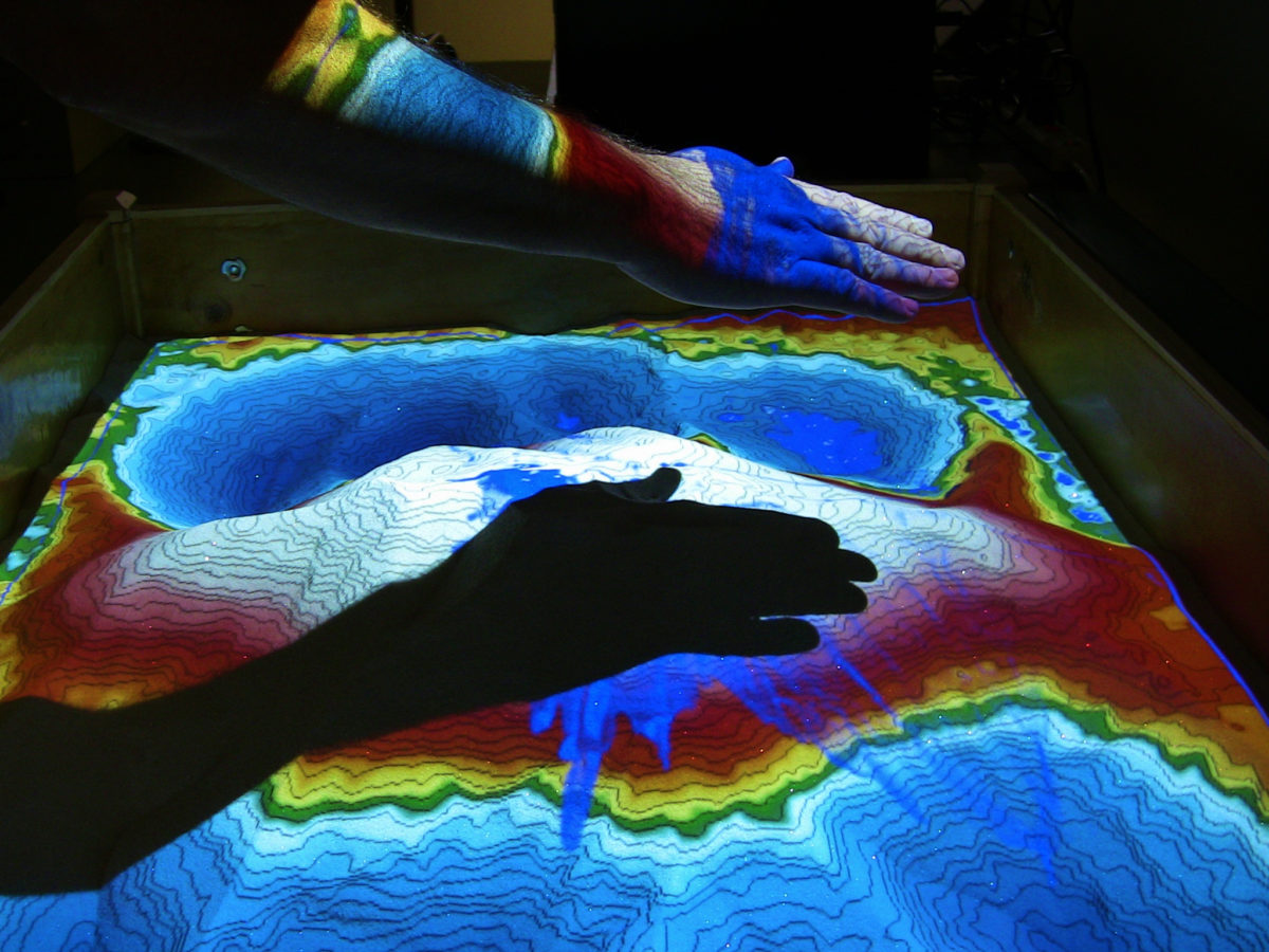
Augmented Reality Sandbox Allows Students To See Three-Dimensional Topographic Maps in Real Time and Even “Make It Rain”
News release by Camille Sicker
Feb. 18, 2015 – Allegheny College has gained a new piece of technology, the Augmented Reality (AR) sandbox, that combines the playfulness of a child’s sandbox with advanced technology to create a learning tool that can be used by students of all ages. When students shape the sand, a Microsoft Kinect 3D camera and a projector with powerful software detect the movement and display a three-dimensional topographic and colored elevation map in real time.
Unlike street maps, topographic maps display three-dimensional characteristics of an area using lines, called contours, to represent elevation above or below sea level. Using topographic maps, engineers know where best to build a road, scientists know where rainwater will flow after a storm and hikers know where a trail is steepest.
Students can have a hard time understanding the connection between a two-dimensional map and a three-dimensional world. But with the AR sandbox, students can build any three-dimensional landscape in the sand and view the changes in topography and elevation as a two-dimensional map.
The AR sandbox began with a group of Czech researchers who posted a YouTube video displaying an early prototype that included elevation maps and a basic form of fluid movement. A team at the W.M. Keck Center for Active Visualization in the Earth Sciences (KeckCaves) at the University of California Davis then added the topographic contour lines and improved the simulated fluid flow to create the current prototype. UC Davis provides the blueprints to build the system as well as the necessary software free of charge on their website.
Built with the support of a grant from the Pennsylvania Department of Environmental Protection and matching funds from Allegheny College, the college’s AR sandbox is attracting the notice of numerous departments and organizations. Creek Connections, a partnership between the college and K-12 schools that focuses on hands-on watershed education, is incorporating the AR sandbox in activities that explore topographic maps, watersheds and stream geology.
“Topographic maps are used across curricula and majors,” said Wendy Kedzierski, project director of Creek Connections. “It’s a basic concept that educators don’t want to spend a lot of time on, and they often assume the students already have an understanding of the concept. So the AR sandbox can quickly fill that learning need through hands-on and visual education. The sandbox brings tactile learning to the map world.”
The college’s geology department plans to take advantage of the sandbox in labs such as introductory physical and environmental geology, upper-level classes including geomorphology and hydrogeology, and independent research projects. Environmental science, biology and computer science are also part of the collaboration and plan to incorporate the AR sandbox into their class curricula.
The sandbox has an additional feature that opens yet another educational door: it can simulate water. Users can “make it rain” simply by extending their hand over an area. Simulated water flow can be used for a wide range of activities, including allowing students to view where rain will fall within watersheds.
“Students in both the Environmental Spatial Analysis and Remote Sensing courses would greatly benefit from the hands-on interaction that the sandbox provides as they learn to read, interpret and utilize topographic maps in support of spatial data collection and analysis,” said Chris Shaffer, Geographic Information System (GIS) manager in the college’s Department of Environmental Science.
Sam Reese, lab technician for the geology and environmental science departments, maintains and facilitates the use of the system. “The AR sandbox is a sign of the future,” he said. “I predict that augmented and virtual reality will play increasingly important roles in the pedagogy of spatially oriented sciences.”